Login
Star users
Poll
Home
>
Sydney
>
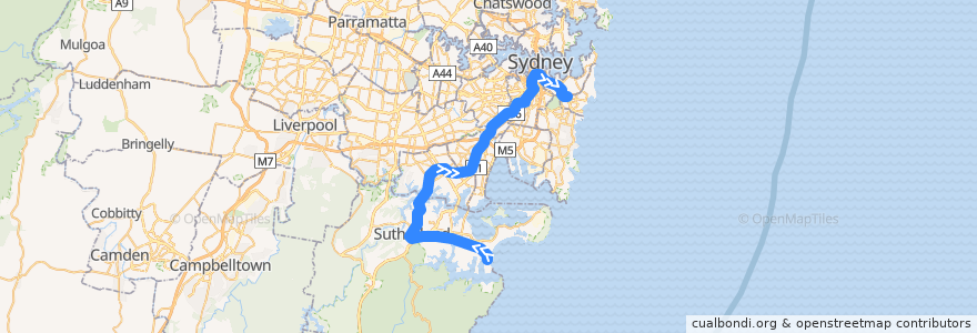
Eastern Suburbs & Illawarra Line
Route
Eastern Suburbs & Illawarra Line
write the first review
See in interactive map
Points of interest near the route
Miranda Medical Center
Emergency Response Services
Tajima Yakiniku
Union Place Hotel
Sydney Distance Education High School
Shenkin Cafe
Westpac
Mix Pizza Bar
Commonwealth
Barista Brothers
Pizza Boccone
Tenkomori
Domino's
Street Library
Subway
Grand Hotel
Walker's Donuts
Money Change
CJ's Tasty Chickens
Olive Tree Kafe & Bar
Oti’
Mohr Fish
Like Noodle
BBQ area
Velvet Underground
Sushi Bar @ William Street
Pharmacy 4 Less
Drift
McDonald's
Ume Burger
Marcus Clark TAFE
Sinbad Kebab
Luke's Bar
My Bangkok
Peace Harmony
El Topo Basement
Taste of Quian
Gracie Barra Bondi
Commercial Office Italy Consulate
The Empire Hotel;Empire Hotel
Devon Café
Firestone
Breena Cafe
Experteeth
Cross Chicken
Integrative Dental - Dr Phillip Stein
Bowery Lane
Papa Gedes Cocktail Bar
Sevens Cafe
7th Heaven
Lindt Chocolate Café
Chatime
Miranda Post Office
Red Wok
Cliff Noble Centre
Budget
Hurstville Private Hospital
Marigold Restaurant
Organik
Cork & Chroma
Stops:
Central
Allawah
Sutherland
Redfern
Jannali
Sydenham
Kogarah
Como
Penshurst
Oatley
Miranda
Tempe
Martin Place
Kirrawee
Mortdale
Arncliffe
Kings Cross
Edgecliff Station, Platform 2
Bondi Junction Station, Platform 1
Cronulla
Carlton
Banksia
Woolooware
Wolli Creek
Rockdale
Gymea
Caringbah
Hurstville
Town Hall