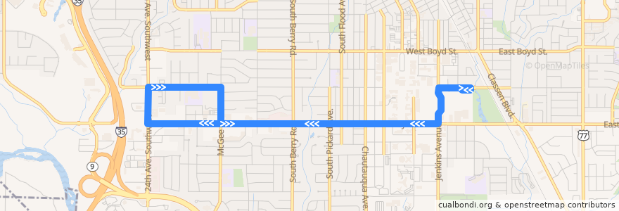
Cualbondi
  • Login
  • Star users
  • Poll
  • Home>
  • Norman>
  • Lindsey West

Route Lindsey West

write the first review

Places that travel to

  • Norman
See in interactive map
Mapa del recorrido Lindsey West de la línea  en Norman.

Points of interest near the route

  • Laughing Tomato
  • Arvest
  • Islamic Society of Norman
  • Chick-fil-A
  • Westside Church of Christ
  • Thai Kum Koon
  • Bentley Hills
  • Church of Christ Student Center
  • Memorial Presbyterian Church
  • St. Stephen's Methodist Church
  • Taco Bell
  • Opie's
  • United States Post Office
  • The Church of Jesus Christ of Latter-day Saints
  • Baja Fresh
  • University Lutheran Chapel
  • Starbucks
  • Chi Alpha Christian Fellowship
  • Betow Fountain
  • Quiznos
  • Saint Anselm Canterbury Association Church
  • OU Federal Credit Union
  • PIttman Parterre
  • StudioU Radio
  • Crossroads
  • Faith Assembly of God Church

Stops:

  • Lindsey/Wylie (eastbound)
  • Lindsey/Lahoma
  • Brooks/Jenkins
  • Brooks/McGee
  • Lindsey/Van Vleet Oval (eastbound)
  • -97.46795320000001, 35.2075515
  • Brooks/Monnett
  • Brooks/24th Ave SW
  • -97.4712348, 35.207553000000004
  • -97.44058220000001, 35.207486800000005
  • -97.45253450000001, 35.2038853
  • Brooks Street Transfer Station
  • -97.44549040000001, 35.2038734
  • -97.47667050000001, 35.204256300000004
  • Lindsey/Flood
  • McGee/Lindsey
  • Whittier Middle School
  • 24th SW/Lindsey
  • -97.46406420000001, 35.203972300000004
  • -97.4708506, 35.2039775
  • Lindsey/Berry (westbound)
  • -97.47615520000001, 35.207544500000004
  • Lindsey/Wylie (westbound)
  • Lindsey/Crown Point
  • -97.45873990000001, 35.203920700000005
  • Lindsey/Van Vleet Oval (westbound)
  • -97.44525300000001, 35.2038774
  • -97.45843670000001, 35.2039193
  • -97.4677944, 35.2046939
  • -97.4514537, 35.2038808
  • Lindsey/Berry (eastbound)
  • -97.46241040000001, 35.2039715

© CualBondi 2009 - 2024

العربية
Deutsch
English
Español
فارسی
Français
Italiano
日本語
한국어
Bahasa Melayu
Português
Русский
Turkish
中文