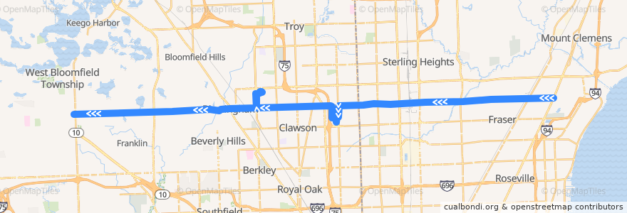
Route 780 WB: Gratiot => Orchard Lake
Places that travel to
Points of interest near the route
Stops:
- -82.9154275, 42.5543587
- 15 Mile / Shell (WB)
- -83.1801241, 42.5475853
- Maple / Crooks (WB)
- Maple / Stephenson (WB)
- -83.27763870000001, 42.544981400000005
- -83.18653760000001, 42.554349300000005
- -83.3109354, 42.5441708
- 15 Mile / Garfield (WB)
- Maple / Tamerlane (WB)
- -82.9002785, 42.5546543
- 15 Mile / Cathedral NS (WB)
- 15 Mile / Chrysler (WB)
- -83.09209410000001, 42.549297800000005
- Maple / Lydia (WB)
- Maple / Maplelawn (WB)
- -83.1864072, 42.5518986
- -83.2293319, 42.546313500000004
- -83.06981130000001, 42.550524700000004
- 15 Mile / Little Mack (WB)
- -82.990288, 42.5522019
- -83.04348730000001, 42.5507365
- Maple / Larchlea (WB)
- Coolidge / Maple (NB)
- -82.9430865, 42.553694400000005
- Maple / Drury NS (WB)
- -82.9310384, 42.554
- Maple / Castle (WB)
- -83.1866717, 42.5541155
- -83.0374955, 42.5509269
- -82.9488371, 42.5535775
- -82.9800251, 42.5526369
- -83.1363401, 42.5485689
- 15 Mile / Koch (WB)
- Maple / Orchard Lake NS (WB)
- -83.35903920000001, 42.5429941
- Maple / Clifton (WB)
- Maple / Northwood NS (WB)
- -83.1457068, 42.548354100000005
- -83.1827262, 42.5475257
- Golfview / Dorchester (WB)
- -82.97862620000001, 42.552700900000005
- -82.9398037, 42.553761300000005
- -83.1862473, 42.549622400000004
- -83.2371643, 42.5460355
- 15 Mile / Van Dyke (WB)
- Maple / Coolidge (WB)
- Maple / Fairfax (WB)
- -83.36226830000001, 42.542901400000005
- -83.234598, 42.546149
- -83.10743740000001, 42.5434889
- John R / Maple (SB)
- -83.11026290000001, 42.5385836
- -83.1478251, 42.5483126
- Maple / Old Woodward (WB)
- Maple / St Andrews (WB)
- -83.3029477, 42.544372800000005
- -83.10519930000001, 42.5492064
- -83.1178543, 42.548973200000006
- 15 Mile / Hayes (WB)