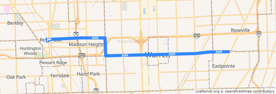
Route 730 EB: Royal Oak => Gratiot
Places that travel to
Points of interest near the route
Stops:
- -83.0623917, 42.476810900000004
- -83.0096273, 42.4778208
- -83.0802225, 42.4764221
- -82.9844154, 42.4784267
- -82.9497439, 42.479670000000006
- -83.05443580000001, 42.4770125
- 10 Mile / Dequindre (EB)
- 10 Mile / Groesbeck NS (EB)
- -83.01724200000001, 42.477627000000005
- -82.98928480000001, 42.478220500000006
- -82.9761587, 42.479004700000004
- 10 Mile / Laetham (EB)
- -83.1043142, 42.4908677
- -83.0416095, 42.477173300000004
- -83.0387127, 42.477190400000005
- 10 Mile / Gibson (EB)
- 11 Mile / Farmer's Market (EB)
- -83.02879920000001, 42.4774094
- 10 Mile / Mound (EB)
- -83.0509706, 42.477067000000005
- -83.08469000000001, 42.480287000000004
- 11 Mile / Hampden (EB)
- 10 Mile / Curie (EB)
- -82.9818276, 42.4786106
- 10 Mile / Warner (EB)
- 10 Mile / Lauren (EB)
- -83.00514220000001, 42.477918700000004
- Dequindre / Greig (SB)
- 10 Mile / Audrey (EB)
- 10 Mile / Romano (EB)
- -83.0872071, 42.4907711
- 11 Mile / Northeastern (EB)
- -83.1352025, 42.4900625
- -82.9614222, 42.4795747
- 10 Mile / Grove (EB)
- 11 Mile / John R (EB)
- -83.13063290000001, 42.4902032
- 10 Mile / Lawrence (EB)
- -83.0264068, 42.4774687
- -83.0847476, 42.4819584
- 10 Mile / Sherwood (EB)
- -83.08502150000001, 42.4884684
- 10 Mile / Firwood (EB)
- 10 Mile / Lorraine (EB)
- -82.9799771, 42.478743300000005
- -83.12201350000001, 42.490425
- 11 Mile / Dorchester (EB)
- -83.06706940000001, 42.476679700000005
- 10 Mile / Van Dyke NS (EB)
- 11 Mile / Vermont NS (EB)
- -83.0709423, 42.476596
- 10 Mile / Garden (EB)
- 10 Mile / Forterra (EB)
- 11 Mile / Rembrandt (EB)
- 10 Mile / Gratiot NS (EB)
- -82.9986568, 42.478046500000005
- -83.0846188, 42.478594
- 10 Mile / Westbrook NS (EB)
- 10 Mile / Malvina (EB)
- 11 Mile / Troy (EB)