Anmelden
Star-Benutzer
Umfrage
Startseite
>
City of Moreton Bay
>
Caboolture Loop
Route
Caboolture Loop
schreibe die erste Bewertung
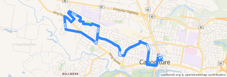
Siehe in der interaktiven Karte
Sehenswürdigkeiten in der Nähe der Route
St Pauls Lutheran Primary
Tullawong State High
Ken Lai Chemist
Caboolture Courthouse
Australia Post Caboolture Distribution Centre
Caboolture Combined Services Hall
Citipointe Church
Rail Trail parking
Subway
Bellygod
Tullawong State Primary School
McDonald's
Food on King
Caboolture Uniting
Gather and Feast
Sushi Bar
Esteem Care Services
Alta-1 College (King St - Caboolture)
Caboolture RSL
Caboolture Post Shop
Carwash
St Pauls
Caboolture Community Action
Pie Face
Commonwealth Bank
Telstra airspot
Duo Cafe
Haltestellen:
Lynfield Drive near Smiths Road
Caboolture Square Shopping Centre
Warner Street near Conondale Avenue
Watt Street near Pearl Crescent
George Street at Caboolture State School
Lynfield Drive near Yaldarra Avenue
George Street near Toohey Street
Warner Street near Watt Street
Smiths Road near Afton Street
Caboolture Central
Lindner Street near Miles Street
Watt Street near Jade Street
Honeysuckle Street near Bluebell Street
Bluebell Street near Hancock Street
King St at Lesley Avenue
Lynfield Drive near Smiths Road
Lesley Avenue near King Street
Lynfield Drive near Dawson Street
George Street near Toohey Street
Miles Street near Meninga Court
Caboolture station, stop D
George Street at Caboolture State School
Lesley Avenue near Jennifer Court
Belcher Street near Linder Street
Lynfield Drive near Yaldara Avenue
Lynfield Drive near Dawson Street