وارد شدن
کاربران ستاره
نظرسنجی
شروع
>
Council of the City of Sydney
>
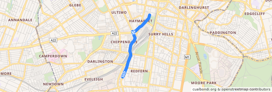
N11
مسیر
N11
اولین نظر را بنویسید
در نقشه تعاملی مشاهده کنید
نقاط مورد علاقه در نزدیکی مسیر
BOQ
Toast Cafe
Ho Jiak
Brooklyn Boy Bagels
Little Caesars
Flyover
Brews Brothers
Rewind Photo Lab Dropbox
Cellar Door
Royal Palace Seafood Restaurant
Masuya Suisan
World Square Pub
Coffee Tea & Me
Beau
UTS Library
Abbotts Hotel
Commonwealth Bank
Central Food Market
Charlottes Little Sister Cafe
Haven Tailouring Coffee Joyously
Michel's Patisserie
ANZ
RSL
No. 1 Rice Noodle House
Pepper Berries
Charlie Chan
The Apprentice
Basket Brothers
Masala Kitchen
Subway
Spice World
Boon Cafe
Brewtopia Plus
Atomic
Domino's
Sussex Centre Food Court
Commonwealth Bank
The Aurora
RaRa Redfern
Top Impression Bakery
The Royal Exhibition Hotel
caffe tiamo
Subway Snacks
Crystal Palace Hotel
World Square Loading Dock Entry
Court House
Goodspace Gallery
Palace Central Cinema Sydney
Saint Germaine Patisserie
Sydney Brewery Surry Hills
Gou Sushi
Xi'an Cuisine
Coffee Trails
Marcus Clark TAFE
insieme
Koko Kawaii
Pho Yen's Vienamese Cuisine
Bancho
Wild Flour
Shortstop Coffee & Donuts