وارد شدن
کاربران ستاره
نظرسنجی
شروع
>
City of Melbourne
>
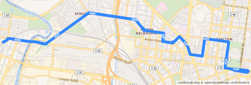
Bus 402: East Melbourne => North Melbourne => Footscray Station
مسیر
Bus 402: East Melbourne => North Melbourne => Footscray Station
اولین نظر را بنویسید
در نقشه تعاملی مشاهده کنید
نقاط مورد علاقه در نزدیکی مسیر
Gate 4 Motorbike Parking
Exhibition Pharmacy
IL Gambero
Lavezzi
Greek Free Church
Bubba Pizza
Cumming Theatre
Gilli
Jazeera Cafe
Coopers Inn
Viet Kitchen
Rick's Place
Scholar & Co
EyeCare Clinic
Sekai Japanese Ramen
Drinking Fountain
Daffney’s
Elms Family Hotel (Permanently closed)
Advance Car Rental
Western Precinct
Parco
Universal Italian
Lickety Split
RMIT Mosque / Islamic Centre
Marion Wine Bar
O Van’s
Drinking Fountain
Noodle House
Market Juice
Toothpicks
Lygon Food Store
Koko Black
NAB
Old Quadrangle Room G18 (Cussonia Court Room 2)
Pickford Pharmacy
Eat Ngon
Cafe Italia
John Curtin
University Hall
The Maj
Australia Post Parcel Locker
Garden View Cafe
Allergy Doctors
Public Toilets (closed)
Public Toilets
PappaRich
Breadtop
Market Lane Coffee
Subway
Rice Bar
Kensington Neighborhood House
Mid Square Coffee
Borsari Ristorante
D.O.C Pizza & Mozzarella Bar
Pioneer Pizza
Melbourne Marriot Hotel
Eastern Precinct Carpark
Chemist Warehouse
ARGI Cafe
Lemon Tree Children's Centre
ایستگاه:
Swanston Street
Carlton Gardens
Royal Australasian College of Surgeons/Victoria Parade
Footscray Station (Bay 17)
144.94127500000002, -37.795837000000006
144.9223815, -37.797239000000005
144.9687604, -37.806929000000004
Footscray Station (Bay 17)
Kensington SC
144.90557, -37.800548
Derby St
144.91838810000002, -37.7995354
St Vincent's Hospital/Victoria Parade
144.9392846, -37.7955251
Royal Australasian College of Surgeons/Victoria Pde
Lygon Street
Wreckyn Street
144.920592, -37.798280000000005
Abbotsford Street
144.96910300000002, -37.804778500000005
Abbotsford Street
St Vincent's Hospital
Rathdowne Street/Grattan Street
Carlton Gardens
Albermarle St
Macaulay Station
Royal Melbourne Hospital/Flemington Road
144.9168721, -37.8004088
Melbourne Museum