Login
Star users
Poll
Home
>
United States
>
California
>
San Diego County
>
La Mesa
La Mesa
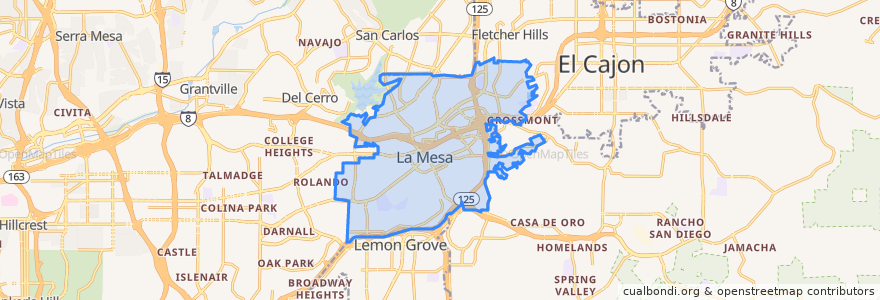
See in interactive map
Routes of public transport
MTS 854
MTS 854X
Orange Line: Arnele Avenue => Courthouse
Orange Line: Courthouse => Arnele Avenue
Sycuan Green Line: 12th & Imperial Transit Center => Santee Town Center
Sycuan Green Line: Santee Town Center => 12th & Imperial Transit Center
Stops
Spring Street
La Mesa Boulevard
Amaya Drive
70th Street
Amaya Drive
La Mesa Boulevard
Grossmont
Grossmont
Spring Street
Points of interest
La Mesa Annex Post Office
Patty's Cafe
McDonald's
Hoffer's Cigar Bar
La Torta
Trolley Stop Deli
Murray Manor Elementary School
La Mesa Adventist Community Church
Hearth House
Citibank
Starbucks
Por Favor
BO-beau kitchen + garden
Ukrainian Catholic Church Center
Lightbulb Coffee
Norms Cocktails
Emerald Oil
La Mesa Pharmacy
Johnny Bs
Chipotle
City Tacos Village Taqueria
Central Congregational Church
Child Evangelism Fellowship San Diego Chapter
Calvary Chapel La Mesa Church School
Chili's
La Mesa Civic Center
United States Post Office
Subway
Carl's Jr.
Rubio's