Login
Star users
Poll
Home
>
United States
>
Pennsylvania
>
Lancaster County
>
Lancaster
Lancaster
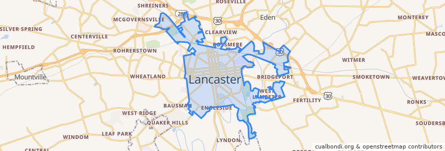
See in interactive map
Routes of public transport
RRTA Route 1 Park City A/Southeast (first weekday am trip)
RRTA Route 5 Grandview/Rossmere
Stops
North Queen and Walnut
North Queen and King Fulton Bank
South Broad and Circle Avenue
Courthouse Duke and Grant
East Farnum and South Queen
College and West New
East End and South Marshall
East King and Lime
West James and North Mary
East Farnum and Church
South Ann and Green
Chesapeake and South Franklin
West James and College Avenue
West Lemon and North Prince
New Dauphin and South Ann
North Prince and West Walnut Street
South Duke and Howard
East King and Ann
South Duke and North
East King and Shippen
South Broad and Clermont
South Ann and Juniatta
East King and Plum
Dauphin and South Lime
-76.3078393, 40.044278500000004
South Lime and Juniatta
New Dauphin and Stevens Avenue
East End and South Ann
South Ann and Chesapeake
South Queen and Vine
Points of interest
Higbee School
American Bar and Grill
Lombardos
Splits & Giggles
Chez Mas
Himalayan Curry & Grill
Espino's Pizza
United States Post Office
The Rabbit & the Dragonfly
LG Health Physicians Cardiothoracic Surgery
Four54 Grill
MRI Group
Reigart Elementary School
Tally Ho
Fenz
WorkParking
Saint Ann School
John J. Jeffreys
Hand Junior High School
CVS
George Washington Elementary School
Old San Juan
Brendeee's Irish Pub
LG Health Physicians Pediatric Hospitalists
Lemon Street Market
Molly's Pub
Wells Fargo
Congregation Shaarai Shomayim
The Heart Group of Lancaster General Health
The Trust Performing Arts Center