로그인
스타 사용자
투표
홈페이지
>
Baltimore
>
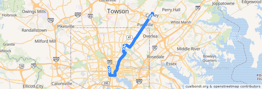
LocalLink 54: Carney
노선
LocalLink 54: Carney
첫 번째 리뷰 작성
여행지
Parkville
Carney
Parkville
대화식지도에서보기
루트 근처의 관심 지점
Howl at the Moon
The Water Street Tavern
Mount Hebron Baptist Church
Subway
Faith Pharmacy
Starbucks
Mount Calvary of the Pentecostal Faith Church
Calvary Christian Church
Saint Pauls Roman Catholic Church
ChargePoint
Au Bon Pain
Third Evangelical Lutheran Church
Unos
Forno
Between Two Buns
Christopher Cemetery 1773
Charity Baptist Church
Saint Johns Church
Northeast Christian School
Friendship Outreach Center
Norma Jean’s
Frank & Nic's West End Grille
Subway
Brown Rice
Baltimore Farmers Market & Bazaar
Luna del Sea Bistro
Miss Shirley's Cafe
Los Rancheros
Chipotle
Royal Restaurant Carry Out
Phillips
Foster Dental Group
Jimmy John's
Mandi Kitchen
Starbucks
Mechanic Theater (Historic)
Goh's Kung Fu
Big Town Carry Out
New Antioch Baptist Church
Basilica Place
Natural Choice
Abundant Life Christian Fellowship
Fogo de Chão
Parkville Driving School
M&T Bank
Capital Grill
Sweet Peach Premium Frozen Yogurt
Oygen
iBrush Family Dental Care
Saturday Morning Cafe
Community Initiatives Academy
CVS Pharmacy
Crazy Johns
Maiwand Grill
China Garden
Shake Shack
The Gallery at Harborplace
Harborplace
Highway Christian Church of the Apostolic Faith
Rite Aid
버스 정류장:
-76.59925150000001, 39.312342
Harford Road & Northern Parkway Northbound
-76.5520238, 39.3632209
-76.59916290000001, 39.3123388