Accesso
Utenti preferiti
Sondaggio
Homepage
>
Mesa County
>
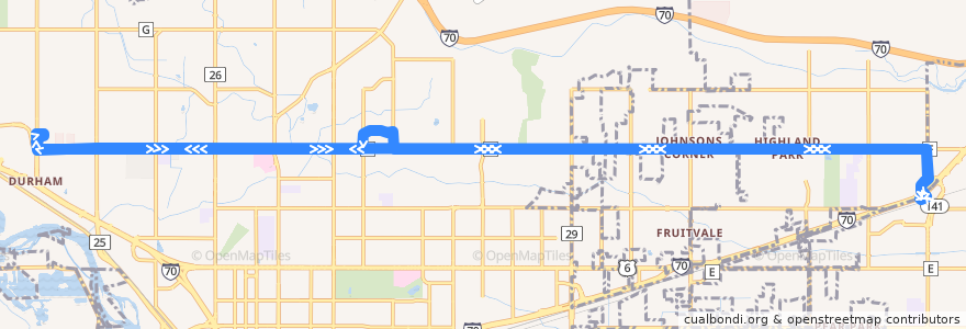
Route 2 Patterson Road
Itinerario
Route 2 Patterson Road
scrivi la prima recensione
Luoghi nel percorso
Grand Junction
Clifton
Visualizza nella mappa interattiva
Punti di interesse vicino al percorso
Which Wich?
Berna B's Restaurant
Starbucks
First Watch
Cafe Court
Starbucks
Professional Self Defense
Jimmy John's
Avis
Appleton Clinics
Colorado Christian University
Papa Murphy's
Wells Fargo Advisors
Redbox
Valley View Hospital Heart & Vascular Center, Grand Junction Clinic
Hot Dog Stand
Bank of the West
Redbox
Chin Chin Chinese Restaurant
Leshae Jones C.M.T
Kuniko's Teriyaki Grill
Mesa County Library Clifton Branch
Redbox
Cedar Point Health - Urgent Care
Subway
Papa John's
Northpointe Bank
Caroylyn Lampshire Skin Care & Reflexology
Costa Vida Fresh Mexican Grill
Charleys Philly Steaks
Core Health Strategies
Coinstar
Fermate:
Patterson Road + East of 28 Road
Patterson Road + East of 25 1/2 Road
Patterson Road @ Long Family Memorial Park
Patterson Road + West of 30 Road
Patterson Road + East of Broken Spoke Road
Patterson Road + East of Grand Cascade Way
Patterson Road + East of Conestoga Circle
Patterson Road + 7th Street (West of Saint Mary's Entrance)
Patterson Road + East of 28 3/4 Road
Patterson Road + East of Foresight Circle
Patterson Road + West of 1st Street
Patterson Road + West of Ford Street
32 Road + South of Patterson Road (Desert Sun Medical)
Patterson Road + West of Round Table Drive
Patterson Road + East of 25 1/2 Road
Patterson Road + East of Orchard Run Drive
Patterson Road + West of 1st Street
Patterson Road + Cross Orchards Historic Farm
Patterson Road + 9th Street (Saint Mary's Pavilion)
Patterson Road + West of Mesa Valley Drive
Patterson Road + East of 30 Road
Patterson Road + East of 27 1/2 Road
Patterson Road + East of 29 1/2 Road
15th Street + South of Hermosa Avenue
Patterson Road + East of 25 Road
Patterson Road + West of 12th Street
Patterson Road + West of 28 1/4 Road
Patterson Road + East of Placer Street
Patterson Road + East of Peace Drive
Patterson Road + West of 26 3/4 Road (By the ATM)
Patterson Road + East of 31 Road
Patterson Road + West of Cris Mar Drive
Patterson Road + West of Beechwood Street
Patterson Road + West of Shoshone Street
Patterson Road + West of 31 1/2 Road
Patterson Road + East of West Indian Creek Drive
Patterson Road + West of 32 Road
Patterson Road + West of 28 1/4 Road
Patterson Road + West of 29 1/2 Road
Patterson Road + West of 29 Road
Patterson Road + West of 7th Street
Patterson Road + East of 12th Street (City Market)
Patterson Road + East of 29 Road (Safeway)
Patterson Road + West of Entrada Street
Patterson Road + West of 31 Road
Patterson Road + West of McMullin Drive
Clifton Transfer Station
Patterson Road + East of 29 1/2 Road
32 Road + South of Patterson Road
Patterson Road + West of 12th Street
Hermosa Avenue + West of 27 1/2 Road (The Commons)
Patterson Road + West of Lodgepole Street