Login
Star users
Poll
Home
>
Mesa County
>
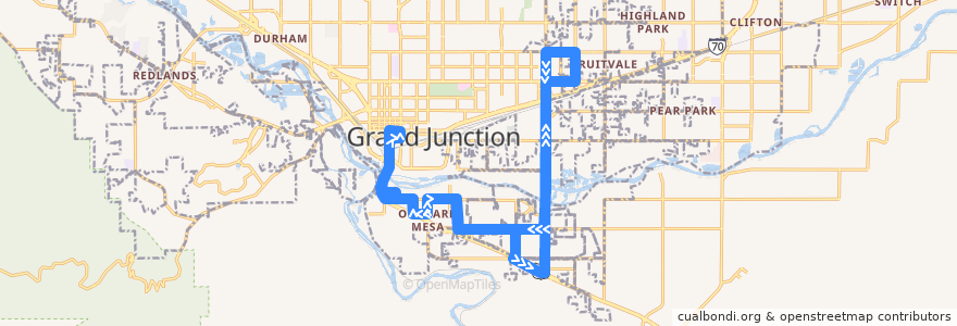
Route 6 - Orchard Mesa
Route
Route 6 - Orchard Mesa
write the first review
Places that travel to
Grand Junction
Orchard Mesa
See in interactive map
Points of interest near the route
Western Union
Little Dipper, Bubbles & Puffenstuff
Orchard Mesa
La Calle 5
Burger King
Home Loan State Bank ATM
Subway
water fountain
Feisty Pint
Nepal Restaurant
Baron's
Colorado Public Radio
Taqueria Guadelajara
Bank of the San Juans
Watson Island Bench
Kiln Coffee Bar
Dragon Treasure
Daylight Donuts
United States Postal Service Fruitvale Branch
Jim's Lawnmower Shop
Java Junction
Nine Province Kung Fu
Every drop matters
Amphitheatre
750 Main Coworking
Mesa County public Library District
Taco Party
Riverside Trail Bench
Church of Christ Western Slope
Alpine Bank
Bin 707 Food Bar
Mesa View Church
Subway
Tropix Hawaiian BBQ
Whitman School
Stops:
Orchard Avenue + West of 29 1/4 Road
29 Road + North of Florida Street
29 Road + North of Shelley Drive
27 1/2 Road + South of Unaweep Avenue
27 Road + South of Unaweep Avenue
North Avenue + West of 29 1/2 Road (Career Center)
B 1/2 Road + East of Arlington Drive
27 1/2 Road + North of B 1/2 Road
Linden Avenue + North of B 3/4 Road (Pull Out)
29 Road + South of Texas Avenue
Unaweep Avenue + West of 27 3/8 Road
29 Road + South of Unaweep Avenue
-108.5149727, 39.063396700000006
Unaweep Avenue + West of Linden Avenue
-108.51527510000001, 39.0638128
29 Road + South of Chipeta Golf Course Entrance
B 1/2 Road + West of 27 3/4 Road
Unaweep Avenue + West of Aspen Street
Unaweep Avenue + West of Aspen Street
Unaweep Avenue + West of Roubideau Street
B 1/2 Road + West of 28 Road
Santa Clara Avenue + East of Highway 50
29 Road + Across from Florida Street
28 1/2 Road + North of B 4/10 Road
29 Road + North of Highway 50 (O.M. Market)
29 1/2 Road + South of Mesa Avenue
29 Road + North of B 1/2 Road
Unaweep Avenue + West of Cedar Street
27 1/2 Road + North of Sunshine Lane
B 1/2 Road + West of 28 Road
B 1/2 Road + West of 29 Road
B 1/2 Road + Across from 27 3/4 Road (City Market)
27 1/2 Road + North of B 1/2 Road
28 1/2 Road + North of B Road
B 1/2 Road + East of Arlington Drive
29 1/2 Road + North of North Avenue (Community Services Campus)
27 Road + North of Milo Drive
29 Road + South of North Avenue
Unaweep Avenue + East of 27 1/4 Road
27 1/2 Road + South of Unaweep Avenue