Accesso
Utenti preferiti
Sondaggio
Homepage
>
Mesa County
>
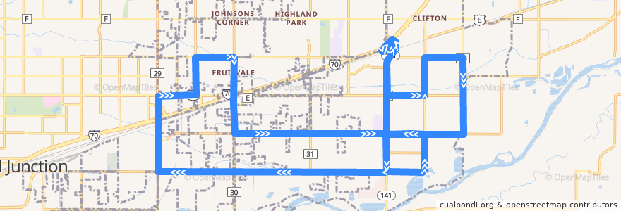
Route 10 Clifton
Itinerario
Route 10 Clifton
scrivi la prima recensione
Luoghi nel percorso
Grand Junction
Clifton
Visualizza nella mappa interattiva
Punti di interesse vicino al percorso
Cedar Point Health - Urgent Care
United States Postal Service Fruitvale Branch
Papa Murphy's
Mesa County Library Clifton Branch
Church of Christ Western Slope
Dairy Queen
Subway
Papa John's
Nine Province Kung Fu
Leon's
Chin Chin Chinese Restaurant
Clifton
Light and Life Chapel
Jimmy John's
Fermate:
30 Road + North of Gunnison Avenue
D Road + West of Wedgewood Avenue
33 Road + North of E Road
33 Road + North of San Felipe Avenue
30 Road + North of Texas Avenue
29 1/2 Road + South of Mesa Avenue
D Road + West of Roberts Road
D 1/2 Road + West of 32 Road
D 1/2 Road + 30 3/4 Road
D Road + Broken Arrow Drive
32 Road + D 3/4 Road
Orchard Avenue + West of Hall Avenue
E 1/2 Road + East of Honeycomb Lane
32 Road + North of D 1/2 Road
Clifton Transfer Station
D Road + West of 30 Road
29 Road + South of North Avenue
D Road + Crystal Drive
D 1/2 Road + West of 33 Road
32 Road + Elm Avenue
North Avenue + West of 29 1/2 Road (Career Center)
D Road + East of 29 Road
D 1/2 Road + 30 1/2 Road
D 1/2 Road + West of Carson Lake Drive
D 1/2 Road + Clear Creek Drive
32 1/2 Road + North of E Road
32 1/2 Road + South of D 1/4 Road
D 1/2 Road + West of Pera Street
32 Road + South of D 1/2 Road
D 1/2 Road + West of 31 Road
29 1/2 Road + North of North Avenue (Community Services Campus)
D Road + East of Alamo Street
D Road + West of Riverwood Drive
D 1/2 Road + East of Colorow Drive
32 1/2 Road + South of E 1/2 Road
32 1/2 Road + South of Lucile Avenue
D Road + West of 31 1/2 Road
32 Road + North of Candlewood
32 Road + North of E Road (Gas Station)
E 1/2 Road + East of Primavera Street
Orchard Avenue + East of 29 1/2 Road
D 1/2 Road + East of 32 3/8 Road
E Road + East of Green Acres Street
32 Road + Kennedy Avenue