Login
Star users
Poll
Home
>
Baltimore
>
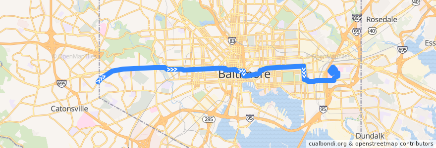
CityLink Blue: Bayview
Route
CityLink Blue: Bayview
write the first review
See in interactive map
Points of interest near the route
Christ Redemed Ministries
Java Joe’s
Lust Baltimore
New Harvest Ministries, Inc.
Poké Workd
Lexington Pharmacy
Staff Only
Papa John's
Down Town
Bentalou Elementary School
Eats
BayBank
Spartan Pizzeria Restaurant
Potbelly
East Baltimore Baptist Church
Mount Vernon Marketplace
Popeyes
Oasis
Marski Bar
2 O’Clock Club
Baltimore Commandment Church
Hip Hop Chicken
Gillis Memorial Community Church
Maiwand Grill
First Apostolic Church
Little Darlings Totally Nude
Saturday Morning Cafe
Peking House
Howl at the Moon
Baltimore City Sheriff's Office
Bottoms Up
Mechanic Theater (Historic)
Ice Cream Store
Francis M Wood Alternative School
Brio
Subway
The Red Boat
Lockerman-Bundy Elementary School
Brantly Baptist Church
Alewife
Sound Stage
Little Free Library
Southeast Station Baltimore Post Office
Caroline Street Methodist Church
Natural Choice
Christ Edmondson Methodist Church
Edible Flavors
The Hipp Cafe
The Chasseur
Saint Andrews Russian Orthodox Church
Baltimore Fire Station 14
Saint Marys Seminary
Phillips
The Local Oyster
Redeeming Love Baptist Church
Baltimore Farmers Market & Bazaar
Saint Pius Memorial Roman Catholic Church
Baltimore Fire Station 40
Samos Restaurant
Jack and Zach
Stops:
-76.56540460000001, 39.2866258
-76.5654093, 39.2866871
-76.5690938, 39.2876865
-76.56918250000001, 39.287680800000004
-76.5634823, 39.2867606
-76.56915760000001, 39.2886463
-76.6931028, 39.2933139
Eastern Avenue & Haven Street Eastbound
Highland Avenue & Gough Street Southbound
-76.562544, 39.2868058
-76.56349370000001, 39.2867012