Anmelden
Star-Benutzer
Umfrage
Startseite
>
Baltimore
>
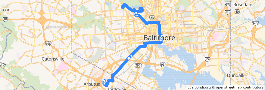
CityLink Yellow: Mondawmin
Route
CityLink Yellow: Mondawmin
schreibe die erste Bewertung
Siehe in der interaktiven Karte
Sehenswürdigkeiten in der Nähe der Route
Fogo de Chão
Dorguth Memorial United Methodist Church
Nando's Peri-peri
Chicken Rico
Impound Lot
BB&T
Au Bon Pain
Fractured Prune
Tin Roof
Café Jovial
Baltimore City Sheriff's Office
Dunkin' Donuts
The Gallery at Harborplace
Harborplace Amphetheatre
America’s Best Wings
Frank & Nic's West End Grille
Inner Harbor Dental Associates
Crazy Johns
Subway
The Hipp Cafe
Oasis
Quest
Pratt Street & South Street Eastbound
University of Maryland Coordinated Care Center
Melody
Maryland Transit Administration Police Force
Subway
Skeeter's Bar
Dunkin' Donuts
Aloha Sushi & Bar
Sharon Seventh Day Adventist Church
Marty's Deli
English Evangelical Lutheran Church of the Messiah
Trinity Baptist Church
Baltimore Fire Station 22
Blu Bambu
Robert L. Bogomolny Library
Mount Calvary of the Pentecostal Faith Church
Natural Choice
Beth Am Congregation
Café Andamiro
The Water Street Tavern
Pacific Carry Out
Starbucks
Joanne's Grill
Poké Workd
Chipotle
Suspended Brewery
Cosi
Subway
Dunkin' Donuts
U S Gas
Gethsemane Baptist Church
Ray's Temple Apostolic Faith Church
Phillips
Christ Apostolic Church
Bible Way Church
Hip Hop Chicken
Uncle Lee's Restaurant
Southwest Baltimore Charter School
Haltestellen:
-76.6157084, 39.3045155
-76.61119400000001, 39.302987200000004
Mondawmin
-76.6228262, 39.3010936
-76.6552813, 39.2376342
North Avenue & McCulloh Street
Fallsway & Chase Street Far-side Northbound
-76.66584010000001, 39.254791000000004
-76.66071000000001, 39.237734
Preston Street & Charles Street Westbound
North Avenue & McCulloh Street
Mondawmin