Login
Star users
Poll
Home
>
Baltimore
>
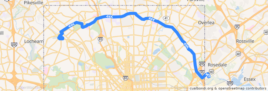
LocalLink 30: Rogers Avenue
Route
LocalLink 30: Rogers Avenue
write the first review
See in interactive map
Points of interest near the route
Liberty Bank
Bank of America
Peking Court
Arlington Methodist Church
Saint Paul & Biddle Medical Associates
Baltimore Hebrew University
Zen West Roadside Cantina
Sofi's Crepes
Saint Marys Seminary
Greenspring Cafe
Adventure Dental & Orthodontics
Strand Theatre Co.
Grace United Methodist Preschool
Andrew Chapel United Methodist Church
Fast Wok
Pizza Bravo Plus
Hillside Chapel
Mount Carmel Church of God in Christ
Best Pizza Subs Wings & More
Clark Burger
Hamilton Business School
Greater Grace Christian Academy
Gil's Pizza
Subway
Frankford Elementary School
American Buffalo Wings
Dayspring
Beth Jacob School
Church of the Redeemer Day School
Church of the Redeemer
Govans Elementary School
Church of the Transfiguration
Rogers Avenue Synagogue
Silver Queen Cafe
Prine Care Pharmacy
Char'd CIty
Atwater's Cafe
Hamilton Presbyterian Church
Mount Zion Baptist Christian School
Grace Lutheran Church of Hamilton
Los Rancheros
Lifebridge Pharmacy
CVS Pharmacy
Garden Sea Chinese Restaurant
BB&T
Emma's Tea Spot
Bethel Temple Church of Christ
House of Praise
Cedarcroft School
Baltimore Fire Station 8
Word of Faith in Christ Christian Church
Hub Sports Bar & Grill
Papa John's
The MarketPlace at Sinai
Moravia Park Primary School
Subway
First Christian Community Baptist Church
Kingdom Hall of Jehovahs Witnesses
Pizza Mart
Subway
Stops:
-76.60951200000001, 39.365116300000004
Northern Parkway & Park Heights Westbound
Northern Parkway & Springlake Way Westbound
Falls Road & Northern Parkway Southbound
Northern Parkway & York Road Near-side Westbound
Preakness Way Between Northern Parkway & Belvedere Avenue Northbound
Northern Parkway & Park Heights Avenue Westbound Far-side
Northern Parkway & York Road Far-side Westbound
Northern Parkway & Roland Avenue Westbound
-76.53009990000001, 39.310148000000005
-76.6459322, 39.361534500000005
-76.5301585, 39.3102005
-76.62475090000001, 39.362114600000005
Northern Parkway & Charles Street Westbound
-76.6643732, 39.353523
-76.63408050000001, 39.3621427
Pulaski Highway & 62nd Street Westbound
Belvedere Avenue & Preakness Way Westbound Near-side
Rosedale Industrial Park
Preakness Way Between Northern Parkway & Belvedere Avenue Northbound
Pulaski Highway & 62nd Street Westbound
Northern Parkway & York Road Westbound
Northern Parkway & Park Heights Avenue Westbound Far-side
Belvedere Avenue & Lanier Avenue Opposite Westbound
-76.6174079, 39.3643504
Northern Parkway & Park Heights Westbound
Belvedere Avenue & Preakness Way Westbound Near-side
Belvedere Avenue & Lanier Avenue Opposite Westbound