Login
Star users
Poll
Home
>
Maryland
>
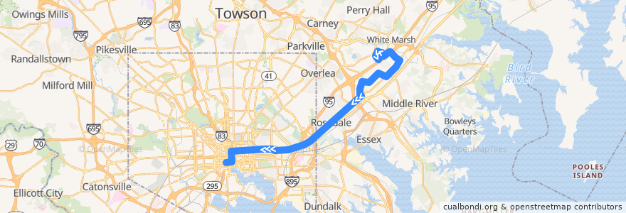
LocalLink 56: Charles Center
Route
LocalLink 56: Charles Center
write the first review
Places that travel to
White Marsh
Rossville
See in interactive map
Points of interest near the route
Dr Rayner Browne Elementary School
Cold Stone Creamery
Starbucks
Oasis
White Marsh Dental Group
Nalley Fresh
Subway
Amazing Grace Evangelical Church
Banthai
Tench Tilghman Recreation Center
Community Church of Christ
Staff Only
Orangeville Methodist Church
Tin Roof
Saint John Baptist Church
Fiesta Mexicans
Atwater Cab
Charity Baptist Church
Crazy Johns
Quiznos
Zhongshan Restaurant
Rosedale Community Evangelical Church
Baltimore City Dental Group
Atwater's
Sijan Cafe
Calvary Presbyterian Church
Bar Louie
Maiwand Grill
The Helmand
Maryland Transit Administration Police Force
Baltimore City Sheriff's Office
Edorito Asian Bistro
Akira Ramen
Starbucks
Mediterranean Halal Food
Uncle Lee's Restaurant
First Colored Baptist Church
Beulah Christian Community Church
Lust Baltimore
Mandi Kitchen
Church of Our Saviour
Peter's
B&O American Brasserie
Red Robin
Rosedale Federal
Subway
Subway
Walgreens
Dr. Marc Singer
Forno
Exeter Memorial Methodist Church
Cosi
Dooby's
Kung Fu Tea
Mount Vernon Saloon
Paul Laurence Dunbar Middle School
Pastore’s
Big Apple Tree Cafe
Jersey Mike's Subs
Baskin-Robbins
Stops:
Franklin Square Drive & Rossville Boulevard Westbound
Franklin Square Hospital Westbound
Sandpiper Circle & White Marsh Health Center Southbound
Philadelphia Road & Baron Place Far-side Southbound
Corporate Drive & Comcast Offices Eastbound
Campbell Boulevard & Hampton Inn Entrance Eastbound
-76.6163799, 39.290466
Philadelphia Road & Long View Avenue Westbound
9103 Franklin Square Drive Opposite Westbound
Philadelphia Road & I-695 Entrance Southbound
Franklin Square Drive & King Avenue Far-side Westbound
8219 Town Center Drive Eastbound
-76.487589, 39.344357200000005
Sandpiper Circle & White Marsh Health Center Southbound
Franklin Square Drive & King Avenue Far-side Westbound
-76.4674122, 39.3695
-76.4841181, 39.350414
Franklin Square Drive & Paula Place Opposite Southbound
9200 Franklin Square Drive Southbound
Town Center Drive & Lowes Theatre Eastbound
Pulaski Highway & 62nd Street Westbound
King Avenue & Heathcliff Drive Far-side Westbound
Campbell Boulevard & Franklin Square Drive Far-side Eastbound
-76.53009990000001, 39.310148000000005
Franklin Square Drive & Canterbury Apartments Opposite Southbound
Philadelphia Road & Long View Avenue Westbound
9200 Franklin Square Drive Southbound
-76.5301585, 39.3102005
Campbell Boulevard & Hampton Inn Entrance Eastbound
Franklin Square Drive & Paula Place Opposite Southbound
Pulaski Highway & 62nd Street Westbound
9103 Franklin Square Drive Opposite Westbound
Philadelphia Road & Fontana Lane
White Marsh Mall
Philadelphia Road & Baron Place Far-side Southbound
Philadelphia Road & Rosedale Heights Avenue
Franklin Square Drive & Canterbury Apartments Opposite Southbound
Campbell Boulevard & Philadelphia Road Eastbound
Corporate Drive & Comcast Offices Eastbound
Philadelphia Road & Hamilton Avenue Westbound
8219 Town Center Drive Eastbound
8098 Sandpiper Circle Southbound
Rossville Boulevard & Shakerwood Road Southbound
8221 Town Center Drive Eastbound
Town Center Drive & Corporate Drive Far-side Eastbound
King Avenue & Heathcliff Drive Far-side Westbound
Campbell Boulevard & Philadelphia Road Eastbound
Philadelphia Road & Rosedale Heights Avenue
Philadelphia Road & Chesaco Avenue Far-side Westbound
8098 Sandpiper Circle Southbound
Philadelphia Road & Fontana Lane
Philadelphia Road & King Henry Circle Westbound
8221 Town Center Drive Eastbound
Philadelphia Road & I-695 Entrance Southbound
Campbell Boulevard & Franklin Square Drive Far-side Eastbound
Town Center Drive & Lowes Theatre Eastbound
White Marsh Mall
Philadelphia Road & Hamilton Avenue Westbound
Fayette Street Plaza Westbound
Sandpiper Circle & Corporate Drive Far-side Eastbound