로그인
스타 사용자
투표
홈페이지
>
메릴랜드
>
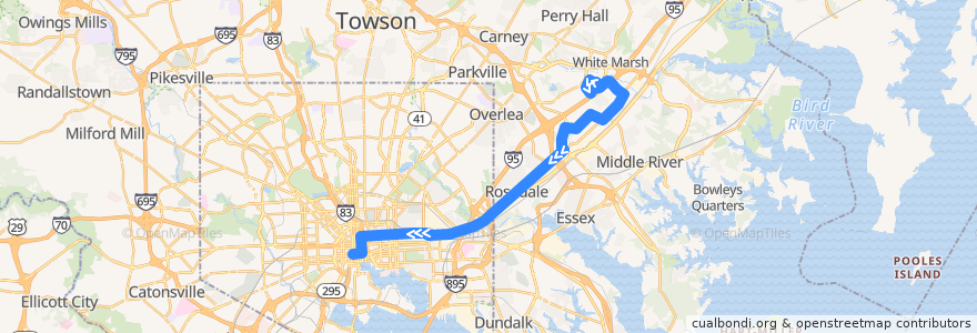
LocalLink 56: Charles Center
노선
LocalLink 56: Charles Center
첫 번째 리뷰 작성
여행지
White Marsh
Rossville
대화식지도에서보기
루트 근처의 관심 지점
Super Chicken BBQ
Alewife
Qdoba
Exxon
HomeSlyce Pizza Bar
Christs Institute Church
Bank of America
Mount Vernon Stable
Mediterranean Halal Food
Tin Roof
The Dog House
Starbucks
Maryland Transit Administration Police Force
Inner Harbor Dental Associates
Baltimore City Dental Group
Saturday Morning Cafe
Paw Prints Pet Hospital
Nina’s
Bottoms Up
Lexington Pharmacy
Charity Baptist Church
Banthai
CVS Pharmacy
Heidi's Brooklyn Deli
Yung’s Carry Out
Fuller Pharmacy
CoreLife
Dr. Liya Pfeffer
Jersey Mike's Subs
Red Robin
Royal Restaurant Carry Out
Staff Only
First Colored Baptist Church
Mechanic Theater (Historic)
Impound Lot
Dave & Buster's
Saint James School
Walgreens
BayBank
Dooby's
Royal Farms
Jai Medical Center
Maiwand Kabob
McDonald's
Tio Pepe Restaurante
Philadelphia Church of the Apostolic Faith
William H Welch Medical Library
Supano's
Faith Baptist Church
Kung Fu Tea
Buffalo Wild Wings
Starbucks
Edorito Asian Bistro
Philadelphia Style Pizza
Subway
Jimmy John's
Prince of Peace Lutheran Church
Rosedale Federal
The Helmand
The Water Street Tavern
버스 정류장:
Philadelphia Road & Rosedale Heights Avenue
8098 Sandpiper Circle Southbound
Franklin Square Drive & Paula Place Opposite Southbound
White Marsh Mall
Franklin Square Hospital Westbound
Pulaski Highway & 62nd Street Westbound
Campbell Boulevard & Philadelphia Road Eastbound
Pulaski Highway & 62nd Street Westbound
Philadelphia Road & King Henry Circle Westbound
Franklin Square Drive & King Avenue Far-side Westbound
8221 Town Center Drive Eastbound
Town Center Drive & Corporate Drive Far-side Eastbound
Franklin Square Drive & Paula Place Opposite Southbound
Corporate Drive & Comcast Offices Eastbound
Philadelphia Road & Fontana Lane
Philadelphia Road & Hamilton Avenue Westbound
Corporate Drive & Comcast Offices Eastbound
-76.487589, 39.344357200000005
Philadelphia Road & Long View Avenue Westbound
Campbell Boulevard & Philadelphia Road Eastbound
Philadelphia Road & Hamilton Avenue Westbound
Franklin Square Drive & Canterbury Apartments Opposite Southbound
Campbell Boulevard & Hampton Inn Entrance Eastbound
Franklin Square Drive & Rossville Boulevard Westbound
8098 Sandpiper Circle Southbound
King Avenue & Heathcliff Drive Far-side Westbound
Philadelphia Road & King Henry Circle Westbound
9200 Franklin Square Drive Southbound
Campbell Boulevard & Franklin Square Drive Far-side Eastbound
9103 Franklin Square Drive Opposite Westbound
-76.6163799, 39.290466
-76.4674122, 39.3695
9103 Franklin Square Drive Opposite Westbound
White Marsh Mall
9200 Franklin Square Drive Southbound
Philadelphia Road & Rosedale Heights Avenue
King Avenue & Heathcliff Drive Far-side Westbound
Philadelphia Road & Baron Place Far-side Southbound
8221 Town Center Drive Eastbound
8219 Town Center Drive Eastbound
-76.4841181, 39.350414
Philadelphia Road & Chesaco Avenue Far-side Westbound
Town Center Drive & Lowes Theatre Eastbound
Sandpiper Circle & White Marsh Health Center Southbound
Philadelphia Road & I-695 Entrance Southbound
Franklin Square Drive & Canterbury Apartments Opposite Southbound
-76.5301585, 39.3102005
Philadelphia Road & I-695 Entrance Southbound
Philadelphia Road & Chesaco Avenue Far-side Westbound
Philadelphia Road & Long View Avenue Westbound
Franklin Square Drive & King Avenue Far-side Westbound
-76.53009990000001, 39.310148000000005
Sandpiper Circle & Corporate Drive Far-side Eastbound
8219 Town Center Drive Eastbound
-76.470622, 39.3678977
Fayette Street Plaza Westbound
Town Center Drive & Lowes Theatre Eastbound
Philadelphia Road & Fontana Lane
Campbell Boulevard & Hampton Inn Entrance Eastbound
Campbell Boulevard & Franklin Square Drive Far-side Eastbound