Login
Star users
Poll
Home
>
Maryland
>
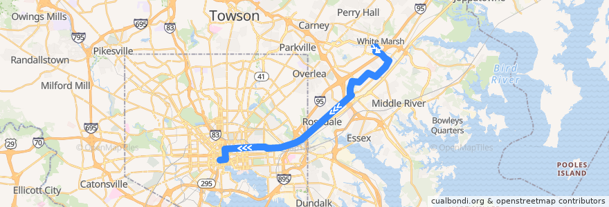
LocalLink 56: Charles Center
Route
LocalLink 56: Charles Center
write the first review
Places that travel to
White Marsh
Rossville
See in interactive map
Points of interest near the route
Cosi
Melody
Maryland Pain Centers
Saint Pauls Methodist Church
Patient First
Baltimore Fire Station 29
Tench Tilghman Recreation Center
Dunkin' Donuts
Dr. Marc Singer
Super Chicken BBQ
BayBank
Noodles & Company
Ledo
Dunkin' Donuts
Starbucks
Faith Baptist Church
Amazing Grace Evangelical Church
White Marsh Psychic
Red Brick Station
Rosedale Community Evangelical Church
Nina’s
Baltimore City Dental Group
Philadelphia Church of the Apostolic Faith
Asian Bistro Express
Oasis
Hustler Club
Prince of Peace Lutheran Church
Mediterranean Halal Food
Starbucks
2 O’Clock Club
The Dog House
Little Darlings Totally Nude
Baskin-Robbins
Five Guys
Java Joe’s
Della Rose's Avenue Tavern
Philadelphia Style Pizza
Baltimore Arena Parking Garage
Community Church of Christ
Johns Hopkins Federal Credit Union
Manor Care
All My Children Child Care Center
Flora
Edorito Asian Bistro
Akira Ramen
Staff Only
The Red Room
Heidi's Brooklyn Deli
Orangeville Methodist Church
McDonald's
Pacific Carry Out
Friendship Baptist Church
Subway
Banthai
Fountain at Charles Center
Church of Our Saviour
Calvary Presbyterian Church
New Pilgrim Baptist Church
Fountain at Charles Center
Bilingual Christian Church
Stops:
Philadelphia Road & Hamilton Avenue Westbound
-76.5301585, 39.3102005
Campbell Boulevard & Philadelphia Road Eastbound
Philadelphia Road & Chesaco Avenue Far-side Westbound
Franklin Square Hospital Westbound
Franklin Square Drive & Paula Place Opposite Southbound
Philadelphia Road & I-695 Entrance Southbound
King Avenue & Heathcliff Drive Far-side Westbound
Campbell Boulevard & Hampton Inn Entrance Eastbound
9103 Franklin Square Drive Opposite Westbound
Franklin Square Drive & Rossville Boulevard Westbound
Philadelphia Road & Fontana Lane
9200 Franklin Square Drive Southbound
Fayette Street Plaza Westbound
White Marsh Park & Ride
Franklin Square Drive & King Avenue Far-side Westbound
Pulaski Highway & 62nd Street Westbound
-76.6163799, 39.290466
Franklin Square Drive & Canterbury Apartments Opposite Southbound
Campbell Boulevard & Philadelphia Road Eastbound
9200 Franklin Square Drive Southbound
Rossville Boulevard & Shakerwood Road Southbound
Campbell Boulevard & Hampton Inn Entrance Eastbound
Campbell Boulevard & Franklin Square Drive Far-side Eastbound
Philadelphia Road & 66th Street Westbound
Philadelphia Road & Baron Place Far-side Southbound
Philadelphia Road & Fontana Lane
-76.4841181, 39.350414
Pulaski Highway & 62nd Street Westbound
Franklin Square Drive & Canterbury Apartments Opposite Southbound
Philadelphia Road & I-695 Entrance Southbound
-76.53009990000001, 39.310148000000005
White Marsh Park & Ride
Philadelphia Road & 66th Street Westbound
Philadelphia Road & Hamilton Avenue Westbound
Campbell Boulevard & Franklin Square Drive Far-side Eastbound
King Avenue & Heathcliff Drive Far-side Westbound
Philadelphia Road & Rosedale Heights Avenue
Franklin Square Drive & King Avenue Far-side Westbound
9103 Franklin Square Drive Opposite Westbound
-76.487589, 39.344357200000005
Franklin Square Drive & Paula Place Opposite Southbound
Philadelphia Road & Chesaco Avenue Far-side Westbound
Philadelphia Road & Long View Avenue Westbound
Philadelphia Road & Rosedale Heights Avenue
Philadelphia Road & Baron Place Far-side Southbound
Philadelphia Road & King Henry Circle Westbound
Philadelphia Road & King Henry Circle Westbound
Philadelphia Road & Long View Avenue Westbound