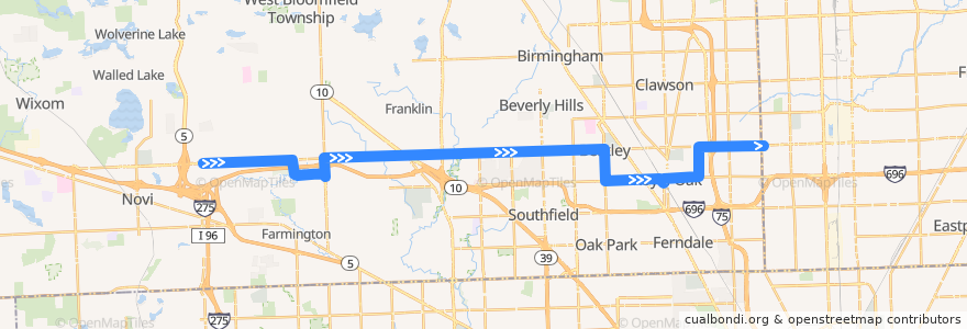
Route 740 EB: Haggerty => Dequindre
Orte, an denen diese Route vorbeiführt
Sehenswürdigkeiten in der Nähe der Route
Haltestellen:
- 12 Mile / Delton (EB)
- 12 Mile / Inkster (EB)
- 11 Mile / West (EB)
- 12 Mile / WSU Oakland (EB)
- 12 Mile / Murray Crescent (EB)
- 11 Mile / Henley (EB)
- 12 Mile / Franklin River (EB)
- -83.12476500000001, 42.4987962
- 11 Mile / Meadowcrest (EB)
- -83.4086544, 42.4976707
- Eleven Mile / Humber NS (EB)
- -83.1212016, 42.504376900000004
- 12 Mile / Dufty NS (EB)
- 12 Mile / Golf Pointe (EB)
- 12 Mile / Bayberry NS (EB)
- 12 Mile / Halsted (EB)
- -83.2806051, 42.5011658
- 12 Mile / Red Leaf (EB)
- -83.1413648, 42.489908500000006
- -83.3011992, 42.500740300000004
- 12 Mile / Sutherland (EB)
- Sherman / Royal Oak Transit Center (SB)
- 12 Mile / Tessmer NS (EB)
- -83.1019485, 42.504830600000005
- -83.28438170000001, 42.501121000000005
- 12 Mile / Southfield (EB)
- 11 Mile / Newport (EB)
- -83.3191436, 42.5002609
- 12 Mile / Oakshire (EB)
- -83.1245655, 42.5043394
- -83.185643, 42.5032088
- Coolidge / Sunnyknoll NS (SB)
- -83.18390120000001, 42.5029527
- 12 Mile / Rollcrest NS (EB)
- -83.1783377, 42.4888862
- 12 Mile / Cumberland (EB)
- -83.4166627, 42.4976143
- -83.3736138, 42.4917345
- -83.088779, 42.5051426
- -83.35825510000001, 42.4992278
- Campbell / Gardenia (NB)
- 12 Mile / Dequindre (EB)
- 11 Mile / Vermont NS (EB)
- -83.2447389, 42.5018867
- 12 Mile / Stansbury (EB)
- -83.1956811, 42.5029647
- -83.23318420000001, 42.5021708
- 12 Mile / Case (EB)
- -83.1520143, 42.4896528
- -83.16247050000001, 42.4893487
- -83.1395184, 42.4899471
- -83.20035890000001, 42.5029191
- -83.15787830000001, 42.4894972
- -83.08443670000001, 42.5052497
- -83.297739, 42.500817000000005
- -83.2130997, 42.5027246
- 12 Mile / Haggerty (EB)
- -83.34683980000001, 42.4995325
- -83.2352493, 42.5021165
- -83.4036435, 42.497793300000005