ログインする
スターユーザー
投票
ホーム
>
Mesa County
>
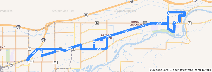
Route 4 - Palisade
ルート
Route 4 - Palisade
最初のレビューを書く
旅行する場所
Palisade
Clifton
インタラクティブマップで見る
ルートの近くの興味のあるポイント
Palisade Livery
Maison la Belle Vie Winery
Chin Chin Chinese Restaurant
Graystone Winery
Red Fox Cellars
Palisade Pharmacy
Plum Creek Winery
Jimmy John's
Mesa County Library Clifton Branch
Cedar Point Health - Urgent Care
Inari's
Palisade Library
357 Bar & Grill
Papa John's
Papa Murphy's
Talon winery
Meadery of the Rockies
Marilac Clinic
Palisade
ストップ:
Highway 6 + East of Lois Street (NO SIGN)
35 Road + South of Highway 6
Front Street + West of 33 Road
Bower Avenue + North of 2nd Street
F Road + West of 35 Road
Highway 6 + West of 36 Road (Church)
Clifton Transfer Station
Front Street + East of 3rd Street
Highway 6 @ Mount Garfield Middle School (Inside Parking Lot)
Iowa Avenue + South of Frontage Road
Highway 6 @ Palisade High School (Inside Parking Lot)
3rd Street + East of Main Street
Iowa Avenue + North of Pendleton Street
Highway 6 + West of 33 Road (NO SIGN)
Elberta Street + North of Highway 6 (Colorado National Bank)
7th Street + West of Peach Avenue (East Valley School)
Elberta Avenue + South of Frontage Road
34 Road + South of Highway 6
Rodeo Road + West of Logan Street
1st Street + East of Majestic Court (by the brick wall)
Highway 6 + West of 35 1/2 Road
Upper Iowa Avenue
F Road + East of 34 1/2 Road (Peachtree/Blossom Care Center)
Elberta Street + North of Crawford Lane
1st Street + Grand Avenue
1st Street + East of Victoria Drive
Kluge Avenue + South of 4th Street
34 1/2 Road + North of F Road (Peachtreet/Blossom Care Center)