로그인
스타 사용자
투표
홈페이지
>
Mesa County
>
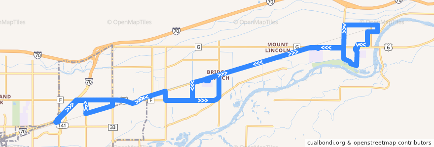
Route 4 - Palisade
노선
Route 4 - Palisade
첫 번째 리뷰 작성
여행지
Palisade
Clifton
대화식지도에서보기
루트 근처의 관심 지점
Plum Creek Winery
Palisade Pharmacy
Maison la Belle Vie Winery
Chin Chin Chinese Restaurant
Meadery of the Rockies
357 Bar & Grill
Mesa County Library Clifton Branch
Papa Murphy's
Inari's
Red Fox Cellars
Graystone Winery
Papa John's
Palisade Livery
Palisade
Cedar Point Health - Urgent Care
Palisade Library
Marilac Clinic
Jimmy John's
Talon winery
버스 정류장:
F Road + East of 34 1/2 Road (Peachtree/Blossom Care Center)
7th Street + West of Peach Avenue (East Valley School)
F Road + West of 35 Road
Upper Iowa Avenue
Highway 6 @ Mount Garfield Middle School (Inside Parking Lot)
Bower Avenue + North of 2nd Street
34 Road + South of Highway 6
Kluge Avenue + South of 4th Street
Front Street + West of 33 Road
Highway 6 + East of Lois Street (NO SIGN)
35 Road + South of Highway 6
Rodeo Road + West of Logan Street
Front Street + East of 3rd Street
Clifton Transfer Station
34 1/2 Road + North of F Road (Peachtreet/Blossom Care Center)
Elberta Avenue + South of Frontage Road
Highway 6 + West of 35 1/2 Road
Highway 6 @ Palisade High School (Inside Parking Lot)
Iowa Avenue + South of Frontage Road
Iowa Avenue + North of Pendleton Street
1st Street + East of Victoria Drive
3rd Street + East of Main Street
1st Street + East of Majestic Court (by the brick wall)
Elberta Street + North of Highway 6 (Colorado National Bank)
Elberta Street + North of Crawford Lane
1st Street + Grand Avenue
Highway 6 + West of 36 Road (Church)
Highway 6 + West of 33 Road (NO SIGN)