Login
Star users
Poll
Home
>
Baltimore
>
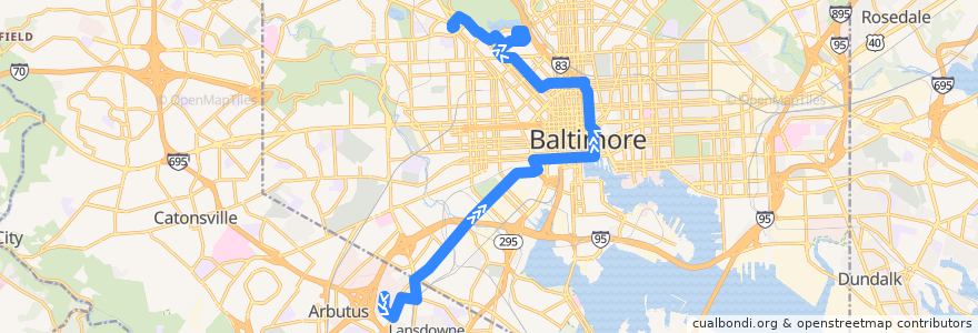
CityLink Yellow: Mondawmin
Route
CityLink Yellow: Mondawmin
write the first review
See in interactive map
Points of interest near the route
Pacific Carry Out
Starbucks
Baltimore Arena Parking Garage
Java Joe’s
Thai Landing
Christ Church of Deliverance
Subway
The Water Street Tavern
2 O’Clock Club
Wye Oak Pharmacy
Trinity Baptist Church
Frank & Nic's West End Grille
Lexington Pharmacy
Kona Grill
Starbucks
Supano's
Mechanic Theater (Historic)
Phillips
Ray's Temple Apostolic Faith Church
The Kabul Fresh Grill
Dunkin' Donuts
Joanne's Grill
Mediterranean Halal Food
Big Apple Tree Cafe
Potbelly Sandwich Works
University of Maryland Medical Center Farmers Market
Morton's The Steakhouse
New Metropolitan Baptist Church
University of Maryland Medical Center Pharmacy
Fellowship of Lights
Bethel Christian School
National Aquarium
Elgin Head Start Center
Suspended Brewery
Baltimore City Sheriff's Office
Natural Choice
Blu Bambu
Chick-fil-A
Hooters
Saint Martins Church of Christ
All My Children Child Care Center
Rams Head Live
Tony’s Grill
The Sidebar
Maryland Institute College of Art
Skeeter's Bar
Oasis
Subway
Chipotle
Inner Harbor Dental Associates
The Spot
Union Baptist Church
Academy of Languages
Jano
BCFD Office of the Fire Marshal
Bottoms Up
Minato
Blaze Pizza
Baltimore City Fire Station 32
Dick's Last Resort
Stops:
Preston Street & Charles Street Westbound
Fallsway & Chase Street Far-side Northbound
North Avenue & McCulloh Street
Mondawmin
Mondawmin
-76.6552813, 39.2376342
-76.66071000000001, 39.237734
-76.6157084, 39.3045155
-76.66584010000001, 39.254791000000004
-76.61119400000001, 39.302987200000004
North Avenue & McCulloh Street
-76.6228262, 39.3010936