Login
Star users
Poll
Home
>
Baltimore
>
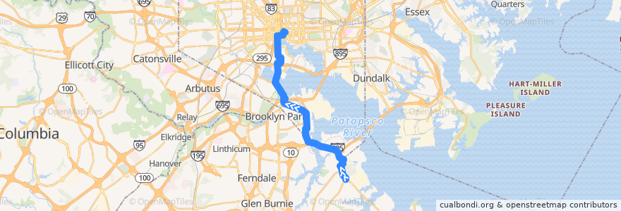
LocalLink 67: City Hall
Route
LocalLink 67: City Hall
write the first review
Places that travel to
Brooklyn Park
See in interactive map
Points of interest near the route
Orchard Beach Fire Company 11
Sullivan's Steakhouse
Mandi Kitchen
Burger Bar
Subway
Baltimore Gracie Jiu-Jitsu
Jewel Box
M&T Bank
Pratt Street & South Street Eastbound
Das Bier Haus
Natural Choice
Oasis
Catholic Community School
Baltimore Fire Station 35
Jan's and Charles' Pizza
Aggio
Wesleyan Methodist Church
South Station Baltimore Post Office
Oygen
America’s Best Wings
All Souls Episcopal Church
Pure Raw Juice
The Red Room
Saint Paul's Evangelical Lutheran Church
Flora
Nick's Fish House & Grill
Starbucks
Davis Planetarium
Maryland Transit Administration Police Force
Capital One
Baltimore Fire Station 38
Chicken Rico
Kona Grill
Steve's Lunch
Church of God of Prophecy
Christ Spiritual Temple
The Cheesecake Factory
Supano's
Gospel Assembly Church
Wow Food Cafe
Lexington Pharmacy
Dunkin' Donuts
BCFD Office of the Fire Marshal
Shake Shack
Bank of America
Ebenezer African Methodist Episcopal Church
Peking House
Bottoms Up
Nalley Fresh
Church of God
Spoons
Harborplace Amphetheatre
Crazy Johns
Southside Saloon
The Kabul Fresh Grill
Tin Roof
Sobo Cafe
The Sidebar
Subway
&pizza
Stops:
City Hall
-76.6084866, 39.2419096
-76.6080029, 39.2916461
-76.6108878, 39.290453
-76.61485780000001, 39.2862032