Log masuk
Pengguna bintang
Undian
Laman utama
>
Baltimore
>
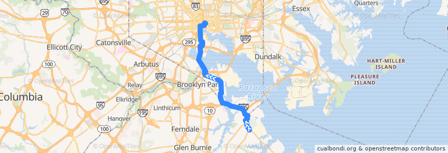
LocalLink 67: City Hall
Laluan
LocalLink 67: City Hall
tulis ulasan pertama
Tempat yang melancong ke
Brooklyn Park
Lihat di peta interaktif
Tempat menarik berhampiran laluan
Southern High School
Subway
Starbucks
Phubs
Bottoms Up
Church of the Lord Jesus Christ of the Apostolic Faith
Howl at the Moon
Hustler Club
Au Bon Pain
Subway
Fried Chicken
Subway
Baltimore City Dental Group
Inner Harbor Dental Associates
Saint Rose of Lima Roman Catholic Church
CVS Pharmacy
Five Guys
Arundel Cove Methodist Church
Harborplace
Peter's
Baltimore City Sheriff's Office
Cans Filling Station
Saint Paul's Evangelical Lutheran Church
The Kabul Fresh Grill
Lexington Pharmacy
Das Bier Haus
Saturday Morning Cafe
South Station Baltimore Post Office
Church of God
Chesapeake Center Alternative
Starbucks
Subway
The Gallery at Harborplace
Brio
Ceremony Coffee
Martini Lutheran Church
Southside Saloon
Hip Hop Chicken
&pizza
Mechanic Theater (Historic)
Maryland Science Center IMAX Theater
Crazy Johns
Leadenhall Street Baptist Church
Brooklyn United Methodist Church
Sullivan's Steakhouse
Oygen
Cosi
Soybeachy
Subway
Bank of America
Saint Josephs Roman Catholic Church
America’s Best Wings
Uncle Lee's Restaurant
Pussycat
Pratt Street & South Street Eastbound
Shake Shack
Unos
Panera Bread
Rice Crook
Saint Marys Star of the Sea School
Perhentian:
-76.6084866, 39.2419096
-76.6080029, 39.2916461
City Hall
-76.61485780000001, 39.2862032
-76.6108878, 39.290453