Accesso
Utenti preferiti
Sondaggio
Homepage
>
Davis County
>
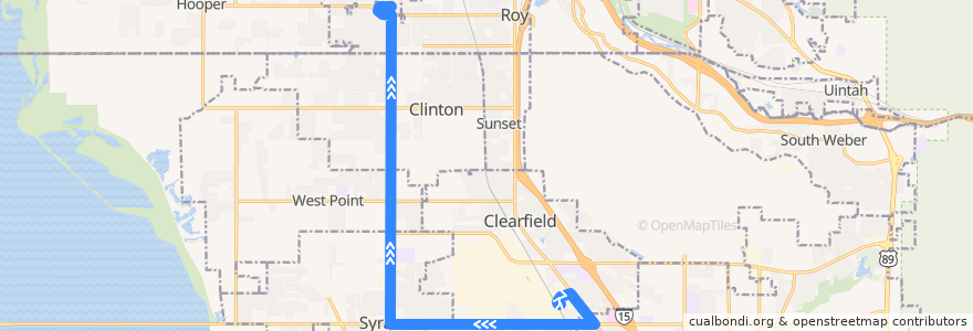
UTA Route 626 West Roy/Clearfield Station (to West Roy)
Itinerario
UTA Route 626 West Roy/Clearfield Station (to West Roy)
scrivi la prima recensione
Luoghi nel percorso
West Point
Layton
Clearfield
Clinton
Roy
Syracuse
Visualizza nella mappa interattiva
Punti di interesse vicino al percorso
The Church of Jesus Christ of Latter-day Saints
Taco Time
Arctic Circle
The Church of Jesus Christ of Latter-day Saints
Tanner Clinic
Jamba Juice
Clinton
Louie's Pizza
Walgreens
The Church of Jesus Christ of Latter-day Saints
Jin's
Maverik
The Pizza Factory
The Church of Jesus Christ of Latter-day Saints
The Church of Jesus Christ of Latter-day Saints
McDonald's
7-Eleven
Rock Ridge Family Medicine
Farr's Fresh
Zaxby's
Subway
Culver's
Little Caesars
Panda Express
Starbucks
Angie's Kinder Academy
Sonic
Weber State University West Campus
Intermountain Healthcare: Syracuse Center
Burrito Grande
Saint Peters Episcopal Church
Grounds for Coffee
Warren's
Pizza Hut
Taco Time
Arby's
Golden West Credit Union
Carl's Jr.
Five Buck Pizza
Tonyburgers
Iceberg Drive Inn
The Church of Jesus Christ of Latter-day Saints - Seminary
Weber State Credit Union
Tanner Clinic
Thai Jasmine
Maverik
Clinton Dental Group
Hibachi House
Samurai Sam's
Manuel's El Burrito
Domino's
North View Pharmacy
Little Caesars
Antelope Elementary School
Papa Murphy's
Blue Rhino
Island View Pharmacy
Ridge View Pharmacy
The UPS Store
New Hope Fellowship