وارد شدن
کاربران ستاره
نظرسنجی
شروع
>
کالیفرنیا
>
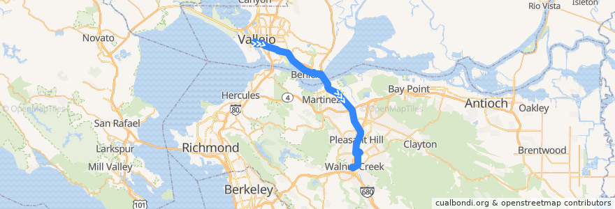
SolanoExpress Yellow Line: Vallejo => Pleasant Hill => Walnut Creek
مسیر
SolanoExpress Yellow Line: Vallejo => Pleasant Hill => Walnut Creek
اولین نظر را بنویسید
مکانهایی که به آنجا سفر می کنند
Walnut Creek
Pleasant Hill
Vallejo
Concord
Martinez
Benicia
در نقشه تعاملی مشاهده کنید
نقاط مورد علاقه در نزدیکی مسیر
The Habit Burger Grill
McDonald's
Gotta Eata Pita
Jack's Restaurant & Bar
Citibank
Benicia Primary School
Dos Coyotes
Rubio's
Saint Patricks High School
Jamba Juice
The Gateway Church
Corner Bakery Cafe
Mare Island Brewing Company
The Counter
Benicia City Hall
Pasta Primavera
Zachary's
SAFE Credit Union
Community Congregational Church
Walnut Creek Intermediate
Pleasant Hill BART
Starbucks
Community Congregational Church
Saint Dominics Priory School
Eureka Restaurant
Rrags Cafe
Tesla Supercharger
First Baptist Church
Peet's Coffee
Boston Market
Moa Korean BBQ
Church of Christ
Starbucks
Willow Pass Dental Care
Coffee Shop
Vallejo Ferry Terminal
Bridge Spot
Starbucks
Subway
Mingles Pizza
Marina Vista Dental
Bank of America
Chipotle
Fire Station Number 2
Travis Credit Union
The Original Pancake House
Starbucks
EMC Seafood and Raw Bar
Starbucks
Citibank
Bank of America
Curtola Park and Ride Hub
Club 1220
USPS Vallejo
Pho Lee Hoa Phat 1
Westamerica Bank
Shell
King Solomon Missionary Baptist Church
Mb Karaoke & Billard
Shanghai Gourmet
ایستگاه:
Walnut Creek BART
East 5th Street & East N Street
Military West & West 14th Street
Curtola Park and Ride Hub
Military West & West 7th Street
Pleasant Hill BART
Pleasant Hill BART
Vallejo Transit Center
Military West & 1st Street
Military West & West 14th Street
Military West & 1st Street
Military West & West 7th Street
East 5th Street & East N Street