Login
Star users
Poll
Home
>
United States
>
California
>
San Joaquin County
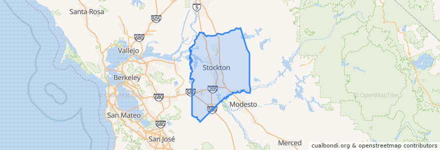
San Joaquin County
See in interactive map
Routes of public transport
Altamont Corridor Express: San José => Stockton (evenings)
Altamont Corridor Express: Stockton => San José (mornings)
Amtrak San Joaquins: Bakersfield => Oakland
Amtrak San Joaquins: Bakersfield => Sacramento
Amtrak San Joaquins: Oakland => Bakersfield
Amtrak San Joaquins: Sacramento => Bakersfield
Flixbus 2006: Los Angeles=> Sacramento
Flixbus 2006: Sacramento => Los Angeles
Places
Stockton
(8)
Escalon
(4)
Lodi
(4)
Manteca
(4)
Lathrop
(2)
Lodi
(2)
Lodi
(2)
Tracy
(2)
Stops
Lodi
FlixBus Stockton
Stockton–San Joaquin Street
Lathrop/Manteca
Lodi
Stockton–Downtown
Lathrop/Manteca
Stockton–Downtown
FlixBus Stockton
Tracy
Tracy
Stockton–San Joaquin Street
Points of interest
Bethel Assembly of God Church
French Camp Post Office
Denny's
Subway
Basil's Spirit's & Sandwiches
Church of All Nations
Lodi City Hall
Starbucks
Shell
Chevron
Saint Bernadettes School
Wells Fargo
Church of Christ
Shell
Subway
Stockton Gospel Mission
Arco
McDonald's
First Congregational Church
Ebenezer African Methodist Episcopal Church
Saint Peters Lutheran Church
KFC
Ira & Luis Cafe
Pentecostal Church of Jesus Christ
Escalon
Old Saint Marys Roman Catholic Church
Lifeseed Christian Fellowship Church
L&L Hawaiian Barbecue
Temple Bethesda
The Golden1