Conecte-se
Usuários estrela
Pesquisa
Início
>
Austrália
>
Queensland
>
Whitsunday Regional
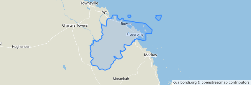
Whitsunday Regional
Veja no mapa interativo
Rotas de transporte público
Blue Shuttle
Bus 841: Town Centre => Queens Beach
Bus 842: Town Centre => Bowen Harbour
Bus 843: Town Centre => Rose Bay
Green Shuttle
Spirit of Queensland: Brisbane → Cairns
Whitsunday Transit route 1
Paradas
Shute Harbour Rd at Loop Road
Murroona St near Bryant Ave hail 'n' ride
Shute Harbour Rd at Orchid Road
Scott Avenue at Whitsunday Street
Mill St at Proserpine
Shute Harbour Rd at Tyree Road
Richmond Road at Centre Point Plaza
Shute Harbour Rd at Plantation Drive
H.I. Aviation
Coral Street at Holborne Street
Herbert Street at Powell Street
Tollington Rd near Soldiers Rd hail 'n' ride
Resort Centre
Shute Harbour Rd near Jasinique Dr (Hail n Ride)
Mackenzie St near Field St hail 'n' ride
Shute Harbour Rd at Ferntree Road
Shute Harbour Rd near Stanley Dr (Hail n Ride)
Argyle Park Road at Emmerson Drive
Horseshoe Bay Rd near Crofton St hail 'n' ride
Mango Tree Corner
Shute Harbour Rd near Port Dr (Hail n Ride)
Field St near Strickland St hail 'n' ride
Shute Harbour Rd at Adv Whitsunday
Palm valley
Bowen
Shute Harbour Rd near Whitsunday Rd (Hail n Ride)
Shute Harbour Rd at Loop Road
Shute Harbour Rd at Stewart Drive
Banksia
Shute Harbour Rd at Hermitage Dr
Pontos de interesse
Whitsunday Regional