Anmelden
Star-Benutzer
Umfrage
Startseite
>
Baltimore
>
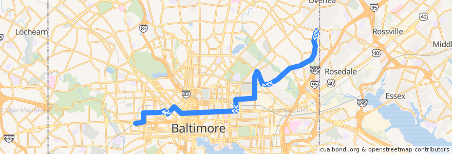
CityLink Pink: West Baltimore
Route
CityLink Pink: West Baltimore
schreibe die erste Bewertung
Siehe in der interaktiven Karte
Sehenswürdigkeiten in der Nähe der Route
Walgreens
Enon Baptist Church
Douglas Memorial Community Church
Dr Rayner Browne Elementary School
Lakewood Elementary School
China Garden
Baltimore
Kingdom Hall of Jehovahs Witnesses
Tio Pepe Restaurante
Patrick Henry School
Fresh Mondays
New Foundations Mansef School
Jai Medical Center
Rite Aid
Prine Care Pharmacy
Café Andamiro
Downtown Baltimore Child Care / Park Avenue
Evans Temple Church of God in Christ
Pizza Boli’s
Mount Vernon Saloon
Church of Our Saviour
Staff and Oversized
Sojourner Douglas College
Taps Fill Station
New Metropolitan Baptist Church
Charity Baptist Church
KFC/Long John Silver’s
Baskin-Robbins
Piazza 27
Ceremony Coffee Roasters
Fort Worthington Elementary School
Dunkin' Donuts
Mount Calvary of the Pentecostal Faith Church
Royal Driving School
Faith Baptist Church
Between Two Buns
Hub Sports Bar & Grill
The Helmand
Atwater's
New Pilgrim Baptist Church
Rising Zion Baptist Church
Canaan Baptist Church
Basilica Place
Faith and Saint Marks United Church of Christ
Kumari
BB&T
Poblano Mexican Grill
First Mount Calvary Baptist Church
American Buffalo Wings
Moorish Science Temple of America
Saint James School
Community Church of Christ
Bethlehem Christian Day School
Nina’s
Best Pizza Subs Wings & More
Canaan Memorial Christian Church
Pacific Carry Out
Edible Flavors
Pharmacy
Erdman Seafood & Kitchen
Haltestellen:
West Baltimore
West Baltimore
-76.5729895, 39.306315000000005
-76.573032, 39.306311400000006
-76.5811913, 39.3059487
-76.5811872, 39.305871200000006