Log masuk
Pengguna bintang
Undian
Laman utama
>
Baltimore
>
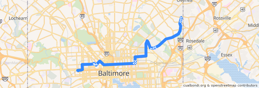
CityLink Pink: West Baltimore
Laluan
CityLink Pink: West Baltimore
tulis ulasan pertama
Lihat di peta interaktif
Tempat menarik berhampiran laluan
Iggie's
The Local Oyster
Sojourner Douglas College
Cultured Charcurerie
Dooby's
Bethel Holy Tabernacle
Dr Rayner Browne Elementary School
All My Children Child Care Center
Fresh Mondays
Agape Christian Baptist Church
Michaelangelo's
Buena Mexican Grill
Prine Care Pharmacy
Royal Driving School
Minato
Melody
Upton Cultural Center
Baltimore Fire Station 27
Erdman Seafood & Kitchen
Amazing Grace Evangelical Church
Johns Hopkins Federal Credit Union
Dunkin' Donuts
Downtown Baltimore Child Care / Park Avenue
Saint John Baptist Church
Staff and Oversized
Canaan Memorial Christian Church
Pizza Boli’s
Apostolic Community Fellowship
Saint Pius Memorial Roman Catholic Church
Kingdom Hall of Jehovahs Witnesses
CUP's Coffeehouse
Piazza 27
The Helmand
BB&T
Friendship Baptist Church
Mount Vernon Pizzeria
Baltimore School For The Arts
Mount Calvary of the Pentecostal Faith Church
Hope Academy
KFC/Long John Silver’s
Good Fortune
Trinacria's
Brown Rice
Tench Tilghman Recreation Center
Edible Flavors
Evans Temple Church of God in Christ
Mi & Yu Noodle Bar
Har Sinai Cemetery
New Union Baptist Church
Saint Katherines School
Jai Medical Center
Douglas Memorial Community Church
Bank of America
Subway
Titus Memorial Church of God
William H Welch Medical Library
Saint James School
Café Andamiro
Fountain Baptist Church
Mount Hebron Baptist Church
Perhentian:
-76.5729895, 39.306315000000005
West Baltimore
-76.5811913, 39.3059487
-76.573032, 39.306311400000006
-76.5811872, 39.305871200000006
West Baltimore