Login
Star users
Poll
Home
>
Baltimore
>
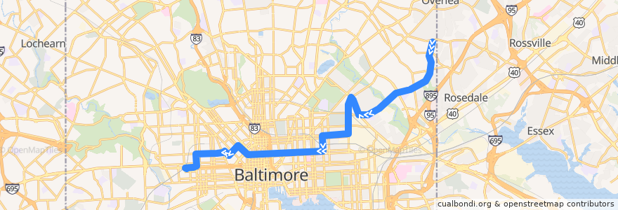
CityLink Pink: West Baltimore
Route
CityLink Pink: West Baltimore
write the first review
See in interactive map
Points of interest near the route
Agape Christian Baptist Church
Good Fortune
Holy Ground Apostolic Faith Church
Khun Nine Thai
Baltimore Tabernacle
Pinch
Crêpes by Mina
Lakewood Elementary School
KFC/Long John Silver’s
Rite Aid
Church of Our Saviour
David Memorial Baptist Church
First Mount Calvary Baptist Church
Saint Katherines School
BB&T
Brown Rice
Saint John Baptist Church
China Garden
Piazza 27
Baltimore
The Dog House
Pizza Boli’s
Dunkin' Donuts
Café Andamiro
Little Caesars
Bentalou Elementary School
Ceremony Coffee Roasters
Church of God
Iggie's
Community Church of Christ
New Metropolitan Baptist Church
Saint Pius Memorial Roman Catholic Church
Thomas G Hayes Elementary School
Staff and Oversized
Mount Hebron Baptist Church
Edible Flavors
Hope Academy
First Colored Baptist Church
Bank of America
Between Two Buns
Grand Central
New Unity Church Ministries
Enon Baptist Church
Melody
Divine Marcy Inc. Counseling & Life Coaching
Kumari
Nail Studio
Baltimore Fire Station 27
Beulah Christian Community Church
Mount Calvary of the Pentecostal Faith Church
Central Congregation of Jehovah's Witnesses
Charity Baptist Church
Mount Olive Evangelical Lutheran Church
Evans Temple Church of God in Christ
Basilica Place
Trinacria's
American Buffalo Wings
Poblano Mexican Grill
Mount Vernon Spine & Rehab
Bethel Holy Tabernacle
Stops:
-76.5729895, 39.306315000000005
-76.573032, 39.306311400000006
West Baltimore
-76.5811872, 39.305871200000006
West Baltimore
-76.5811913, 39.3059487