وارد شدن
کاربران ستاره
نظرسنجی
شروع
>
Baltimore
>
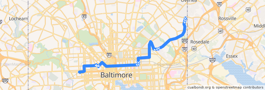
CityLink Pink: West Baltimore
مسیر
CityLink Pink: West Baltimore
اولین نظر را بنویسید
در نقشه تعاملی مشاهده کنید
نقاط مورد علاقه در نزدیکی مسیر
Moorish Science Temple of America
Fresh Mondays
Poblano Mexican Grill
Iggie's
The Helmand
Bethel Christian School
New Metropolitan Baptist Church
Melody
Mt. Vernon Pharmacy
Nail Studio
Mount Pleasant Christian School
Ceremony Coffee Roasters
Saint Pius Memorial Roman Catholic Church
Church of Our Saviour
New Pilgrim Baptist Church
Saint Marys Seminary
Sanctuary Church
Mount Olive Evangelical Lutheran Church
CUP's Coffeehouse
Brown Rice
New Foundations Mansef School
Old Landmark Baptist Church
Thomas G Hayes Elementary School
Union Baptist Church
Greater Olivet Baptist Church
Mount Vernon Stable
City Cafe
Good Fortune
Kumari
Staff Only
Little Caesars
Saint James Convent
Royal Driving School
Faith Baptist Church
Saint Katherines School
Crêpes by Mina
David Memorial Baptist Church
Mount Hebron Baptist Church
Bring It To Life Ministries
Tench Tilghman Recreation Center
Central Congregation of Jehovah's Witnesses
Shareef's House of Wraps
Downtown Baltimore Child Care / Park Avenue
Baskin-Robbins
Pizza Boli’s
Baltimore Fire Station 27
William H Welch Medical Library
Rite Aid
Safa Pizza
Saint Wenceslaus School
Star of Bethlehem Spiritual Temple
Café Andamiro
Chinese Boxing Academy
China Garden
Saint John Baptist Church
Minato
Pacific Carry Out
Mount Vernon Pizzeria
School of the Most Precious Blood
Rising Zion Baptist Church
ایستگاه:
West Baltimore
-76.573032, 39.306311400000006
-76.5811913, 39.3059487
-76.5729895, 39.306315000000005
West Baltimore
-76.5811872, 39.305871200000006